You're viewing a lighter version due to slow connection
Choquequirao Trek 2026
Deep inside the Apurímac Canyon, reachable only on foot through one of the most dramatic landscapes in the Andes, Choquequirao stands as the least-visited and most awe-inspiring Inca citadel in Peru. A place where silence still belongs to those willing to earn it.
Showing 1 Choquequirao treks
Moderate - HardFrom $525 USD
Choquequirao Trek 4 Days 3 Nights
4 Days / 3 Nights
Moderate - Hard
Trek to Choquequirao in 4 days, exploring stunning Andean landscapes, the Apurímac Canyon, and the impressive Inca ruins.
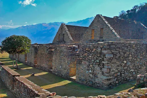
Tucked between two deeply carved ridges at the headwaters of the Apurímac River, Choquequirao — which translates from Quechua as "Cradle of Gold" — is a vast Inca ceremonial and urban complex dating from the late 15th century. Historians attribute its construction to the Inca ruler Túpac Yupanqui, later expanded under Huayna Cápac, and believe it served as both a royal estate and a strategic administrative center controlling access routes between the highlands and the Amazon basin.
What makes Choquequirao extraordinary is its sheer scale and its state of preservation. The visible, restored sector covers roughly 30 to 40 hectares, but ongoing archaeological surveys suggest that the total occupied area — including terraces, storage structures, and outlying ceremonial platforms — could extend to well over 650 hectares. Current estimates indicate that only about 30 to 40 percent of the site has been excavated. The rest remains hidden beneath centuries of cloud forest vegetation, waiting.
Unlike Machu Picchu, which was rediscovered by Hiram Bingham in 1911 and gradually made accessible by rail, Choquequirao has never had a road built to it. Every visitor must arrive on foot, after two days of trekking through one of the deepest river canyons in South America. This inaccessibility is the very thing that preserves its atmosphere: on any given day, fewer than 30 people may walk its terraces.
A site still revealing itself: As recently as 2008, archaeologists uncovered the Llama Terraces — a set of agricultural platforms decorated with white stone inlays depicting a procession of llamas and alpacas, unique in Inca art. Such discoveries are still being made. Every Choquequirao trek is, in a small way, a journey into ongoing history.
Architecture and Main Sectors of the Citadel
Choquequirao shares many architectural principles with Machu Picchu — carefully fitted stone walls, trapezoidal doorways, agricultural terracing cascading down steep slopes — but the spatial organization reflects a different ceremonial logic, shaped by the dramatic geography of the Apurímac gorge. The site is divided into several distinct sectors, each with a specific function.
🏛️ Upper Platform & Usnu
The highest point of the main complex contains the Usnu — a ceremonial platform used for rituals and astronomical observations. From here, the views over the canyon and toward the snowcapped peak of Padreyoc (5,400 m) are among the most dramatic at any Inca site in Peru.
🪨 Main Plaza (Huayrana)
The large central plaza, flanked by kallankas (long rectangular halls used as assembly spaces), functioned as the civic and ceremonial heart of Choquequirao. The quality of the stonework here — perfectly cut granite blocks fitted without mortar — rivals the finest masonry at Cusco's Coricancha temple.
🦙 Llama Terraces
One of the most recent and remarkable discoveries at the site: a series of agricultural terraces on the lower slopes whose retaining walls are decorated with white limestone inlays depicting llamas in profile — a rare example of pictorial art integrated directly into Inca architecture. Accessible on the extended 5-day version of the trek.
💧 Water Channels & Fountains
Like all major Inca complexes, Choquequirao features a sophisticated hydraulic system. Stone-lined water channels (acequias) run throughout the site, directing spring water to ceremonial fountains and residential areas. The engineering is so precise that several channels still carry water today, over 500 years after their construction.
🌿 Residential Sectors
Several distinct residential clusters have been identified, suggesting a stratified population of priests, administrators, agricultural workers, and their families. The houses follow the characteristic Inca pattern: single-room rectangular structures organized around shared patios, with storage niches set into the walls.
📐 Altitude & Orientation
The citadel sits at 3,085 meters above sea level, on a ridge between two tributaries of the Apurímac River. Its orientation — facing northeast toward the sunrise — follows standard Inca astronomical alignment principles. The site commands views of several sacred mountain peaks (Apus) considered protective deities by the Inca.
The Standard Choquequirao Trek: 4 Days, 3 Nights
The classic Choquequirao Trek departs from Cusco by road to the village of Cachora (2,900 m), the main trailhead for the route. From Cachora, the trail descends dramatically into the Apurímac Canyon before climbing the opposite wall to the citadel. The round trip covers approximately 54 kilometers with a total elevation gain of over 3,000 meters across four days.
Day 1 — Cachora → Capuliyoc Viewpoint → Chiquisca (2,900 m – 1,900 m)
After arriving in Cachora by road from Cusco (approximately 3.5 hours), the trek begins with a gradual climb to the Capuliyoc viewpoint (2,915 m), which offers the first dramatic view of the Apurímac Canyon and a distant glimpse of the Choquequirao terraces on the far wall. From here the trail descends steeply through dry scrub forest and cactus to the campsite at Chiquisca (1,900 m). Estimated walking time: 5 to 6 hours.
Day 2 — Chiquisca → Playa Rosalina → Marampata → Choquequirao (1,500 m – 3,085 m)
The most demanding day. The trail descends further to cross the Apurímac River at Playa Rosalina (1,500 m) — the lowest point of the entire route, where the canyon air is warm and the turquoise river rushes below. From the bridge, the trail immediately begins an unrelenting 1,500-meter climb to the ridge above, passing through the hamlet of Marampata (2,850 m) before reaching the citadel itself at 3,085 m. Estimated walking time: 7 to 8 hours.
Day 3 — Exploration of Choquequirao
A full day dedicated to exploring the different sectors of the citadel with a certified guide. The morning visit covers the Main Plaza, the Usnu, the residential sectors, and the ceremonial fountains. After lunch at camp, the afternoon descends to the Llama Terraces (on the extended route), one of the most photographed and recently uncovered sections of the site. Sunset from the upper platform, looking across the canyon toward the Vilcabamba range, is a defining moment of the trek.
Day 4 — Choquequirao → Playa Rosalina → Cachora → Cusco (3,085 m – 2,900 m)
The return follows the same trail in reverse — descending to the Apurímac River and then climbing back up the canyon wall to Cachora. Though it covers familiar ground, the changed light and physical awareness built over three days give the landscape a different character on the way back. Transport from Cachora returns trekkers to Cusco in the late afternoon or evening. Estimated walking time: 7 to 8 hours.
Extended Route: Choquequirao to Machu Picchu (8–10 Days)
For trekkers seeking one of the most complete Andean wilderness experiences available anywhere in South America, the Choquequirao to Machu Picchu route continues beyond the citadel, crossing the high pass of Yanama (4,900 m) and descending through the remote valleys of Totora and La Playa before joining the Santa Teresa River valley and arriving at Aguas Calientes — the gateway to Machu Picchu. This route passes through landscapes ranging from subtropical canyon scrub (1,500 m) to glaciated high passes (4,900 m) within a single trek, crossing ecosystems that few travelers ever witness. No other trekking circuit in Peru offers the same combination of depth, remoteness, and archaeological significance.
Best Time for the Choquequirao Trek
The Choquequirao Trek is open throughout the year, unlike the Inca Trail, which closes in February. However, seasonal conditions have a significant effect on trail quality and overall experience.
May – June
⭐ Ideal conditions — dry trails, clear canyon views, comfortable temperatures. Vegetation lush after the rains.
July – August
⭐ Peak dry season — best trail conditions, maximum visibility. The most popular months. Book ahead.
September – October
✅ Shoulder season — quieter trails, some afternoon cloud, still reliable. A good option to avoid peak crowds.
April
✅ Transition month — rains diminish, vegetation vivid green, fewer groups. Trails may be muddy in places.
Nov – Mar
🌧️ Rainy season — trail open but steep sections become slippery. The canyon flora is at its most spectacular. For experienced trekkers.
No annual closure: Unlike the Inca Trail, which closes every February for maintenance, Choquequirao has no mandatory closure period. This makes it an excellent alternative for travelers whose dates fall in February, or anyone who wants a guaranteed permit without months of advance planning.
What to Prepare for the Choquequirao Trek
👟 Footwear & Layers
Sturdy waterproof hiking boots with ankle support are essential — the canyon trail combines loose scree, exposed roots, and stone steps, often on steep gradients. Temperatures swing from near-freezing at the citadel at night to over 30°C at the canyon floor during the day. Layering is not optional on this trek.
🎒 Load Management
Your personal daypack should not exceed 8 kg on the trail. Porters or mules carry the main equipment duffel (maximum 7 kg of personal gear per person). Trekking poles are strongly recommended — the descent from the citadel to the river is long, steep, and hard on the knees without them.
🌡️ Altitude & Heat Awareness
The Choquequirao Trek combines altitude (up to 3,085 m at the ruins, higher on extended routes) with intense heat in the canyon bottom. Acclimatize in Cusco for a minimum of two full days before departure. Stay hydrated — the combination of altitude and physical exertion in warm canyon air accelerates dehydration significantly.
🔋 Power & Connectivity
There is no electricity or mobile network along the Choquequirao Trail. Bring a power bank with sufficient capacity for your devices. A solar charger can supplement on clear days. Inform family or contacts of your itinerary before departure — emergency communication, if needed, relies on guides' satellite communication equipment.
🧴 Sun & Insect Protection
UV exposure at altitude is intense, especially on south-facing canyon walls with little tree cover. Apply SPF 50+ sunscreen at every stop. The lower canyon sections and river crossing areas have insects, particularly during the wet season — a DEET-based repellent is worth the extra weight in your pack.
🏕️ Camping Comfort
All organized treks include a sleeping tent, foam mattress, and full meal service. Bring a sleeping bag rated to at least -5°C — nights at the citadel campsite are cold, especially during the dry season when clear skies allow rapid heat loss. A lightweight inflatable sleeping pad adds meaningful insulation from the ground.
Choquequirao vs Other Andean Treks
Understanding how the Choquequirao Trek compares to other major routes in the region helps travelers choose the right experience for their fitness level, available time, and expectations.
Trek
Duration
Max. Altitude
Difficulty
Key Feature
🏔️ Choquequirao (Standard)
4 days / 3 nights
3,085 m
Moderate – Hard
The least-visited major Inca citadel in Peru. No permit cap, no crowds. A genuine sense of discovery on every day of the trek.
🗺️ Choquequirao – Machu Picchu
8–10 days / 7–9 nights
4,900 m (Yanama Pass)
Hard – Very Hard
One of the most complete trekking circuits in South America. Crosses five distinct ecosystems. Ends at Machu Picchu. For well-prepared trekkers only.
🥾 Classic Inca Trail
4 days / 3 nights
4,215 m (Warmiwañusca)
Moderate
Iconic stone-paved road with multiple Inca ruins. Ends at Machu Picchu via the Sun Gate. Strict daily permit limit — book months in advance. Closed every February.
🏔️ Salkantay Trek
5 days / 4 nights
4,600 m (Salkantay Pass)
Moderate – Hard
Dramatic high-altitude pass beneath Peru's second-highest peak. Cloud forest, hot springs, ends at Aguas Calientes. Open year-round, no permit cap.
Our team at Viajes Machupicchu Travel can advise on the best route based on your current fitness level, available dates, and the kind of experience you're looking for. Contact us — we trek these routes ourselves and know every camp and viewpoint along the way.
Frequently Asked Questions – Choquequirao Trek
Choquequirao is a ceremonial and administrative Inca citadel built in the 15th century, located at 3,085 meters above sea level at the edge of the Apurímac Canyon. It is sometimes compared to Machu Picchu because of its scale, the quality of its stonework, and its importance within the Inca political and religious system — but it differs in one fundamental respect: there is no road leading to it. The only way to arrive is on foot, through two days of trekking across the canyon. That inaccessibility is precisely what preserves the extraordinary atmosphere of solitude that Machu Picchu can no longer offer.
The Choquequirao Trek is rated moderate to demanding. The main challenges are the steep elevation changes — particularly the 1,500-meter descent and ascent of the Apurímac Canyon on Day 2, which is long and relentless — and the cumulative fatigue of carrying a daypack across four days of mountain terrain. No technical skills are required, but prior experience with multi-day hikes, good cardiovascular fitness, and a minimum of two days of acclimatization in Cusco before departure are important preparation steps. Trekking poles make a meaningful difference on the canyon ascents.
Unlike the Inca Trail, the Choquequirao Trek does not require a pre-purchased permit linked to a fixed daily visitor quota. Access to the site involves an entrance fee collected at the archaeological zone, but there is currently no reservation system and no cap on daily visitors. This means the route is available with considerably less advance planning than the Inca Trail. That said, regulations can change — consult with a licensed tour operator in Cusco before your trip to confirm current access requirements.
The most common version of the Choquequirao Trek takes 4 days and 3 nights, completing a round trip from the trailhead at Cachora. A 5-day version adds a full second day at the ruins for a more thorough exploration of all sectors, including the Llama Terraces. For those with more time and a high fitness level, extended routes of 8 to 10 days connect Choquequirao with Machu Picchu via the high passes of Yanama, offering one of the most complete Andean trekking circuits in existence.
On the standard 4-day route, the highest point is the Capuliyoc viewpoint at approximately 2,915 meters and the citadel itself at 3,085 meters. The lowest point is the Apurímac River crossing at around 1,500 meters. The extended Choquequirao to Machu Picchu route crosses the Yanama Pass at approximately 4,900 meters above sea level — a significant altitude requiring careful preparation and a full acclimatization period in Cusco beforehand.
Yes — the Choquequirao Trek remains open throughout the year, including February. This is one of its significant advantages over the Inca Trail, which closes every February for maintenance. The rainy season (roughly November through March) brings more challenging trail conditions, with some steep sections becoming slippery after sustained rainfall. However, the trek is entirely feasible in the wet season for prepared and experienced trekkers, and it offers a noticeably quieter and greener experience than the dry season months.
Choquequirao receives a very small fraction of the visitors that Machu Picchu sees each year. While Machu Picchu hosts upwards of one million visitors annually, Choquequirao typically sees fewer than 6,000 trekkers per year. On any given day, it is common to encounter fewer than 20 to 30 people at the site. This makes Choquequirao one of the most uncrowded significant archaeological sites on the continent — a stark contrast to the organized entry queues and timed visitor slots required at Machu Picchu.
There is no legal requirement to hire a guide for the Choquequirao Trek. However, independent trekking on this route presents real challenges: the trail is not consistently marked, river levels can change quickly after rainfall, cell coverage is essentially absent along the entire route, and the ruins themselves lack interpretive signage explaining the different sectors and their functions. A certified local guide adds meaningful value in terms of safety, route navigation, and archaeological understanding. For first-time visitors to the canyon, organizing a supported trek with a reputable agency in Cusco is the strongly recommended approach.
The Choquequirao Trek is a fully camping-based experience. There are no hotels, hostels, or lodges along the trail. Designated campsites are located at Chiquisca, Playa Rosalina (near the river), Marampata, and within the archaeological zone itself. Organized tours provide all camping equipment, including sleeping tents, a dining tent, sleeping mats, and a portable kitchen. Trekkers should bring a personal sleeping bag rated to at least -5°C, as nights at altitude are genuinely cold, especially during the dry season.
Current archaeological estimates suggest that between 30 and 40 percent of the total Choquequirao complex has been cleared and studied. The visible and restored area covers approximately 30 to 40 hectares, but the full extent of the site — including agricultural terraces, outlying storage platforms, and secondary structures extending across the surrounding ridges — may cover over 650 hectares in total. New sectors continue to be uncovered; the Llama Terraces were only discovered and cleared as recently as 2008. In practical terms, this means trekkers visiting Choquequirao today are experiencing a site that is still genuinely emerging from centuries of forest overgrowth.
Certifications
ISO 9001:2015
Commitment to quality. We are certified with ISO 9001, ensuring excellence in our
services.
ISO 14001:2015
We prioritize environmental sustainability by reducing our impact on the
planet.
Official Operator
Official travel agency and tour operator. Unique and high-quality experiences.
Traveler’s Choice 2025
Recognition of our dedication and excellence in travel experiences.
Recommended by
Information Before Traveling to Machu Picchu
Trips to Machu Picchu, Cusco Tour Packages include hotels, guides, transportation, trains, entrance fees, museums, and transfers.
 Moderate - Hard
From $525 USD
Moderate - Hard
From $525 USD


